Introduction
Within This Page
Flooding is the overflow of excess water from a water body onto adjacent lands. FEMA more specifically defines a flood as a general and temporary condition of partial or complete inundation of normally dry land areas from (1) the overflow of inland or tidal waters or (2) the unusual and rapid accumulation or runoff of surface waters from any source.
One or more water bodies can contribute to flooding at a given site—a river, stream, ocean, bay, lake, pond, storm water retention/detention area, etc.—depending on local topography and hydraulic/hydrologic conditions.
Flooding can damage buildings and their contents in many ways, but the most common flood damages arise from:
- direct damage during a flood from inundation, high velocity flow, waves, erosion, sedimentation and/or flood-borne debris,
- degradation of building materials, either during the flood or sometime after the flood, and
- contamination of the building due to flood-borne substances or mold.
The likelihood and impacts of these damages can be minimized through the use of siting, design, construction and maintenance practices appropriate to floodplain areas. In the United States, these practices are based largely on the National Flood Insurance Program (NFIP) and its regulations governing land management and use (44 CFR Part 60).
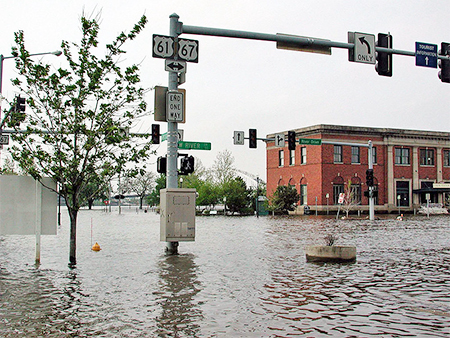
Mississippi River Flooding, 2001.
Photo Courtesy of FEMA
Description
Achieving a flood-resistant building depends upon several things:
-
Identifying the source, nature and severity of flood hazards affecting potential building sites,
-
Selecting a building site where flood hazards are eliminated or minimized,
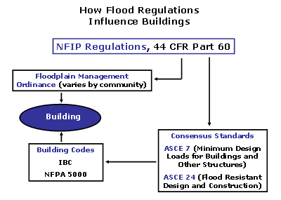
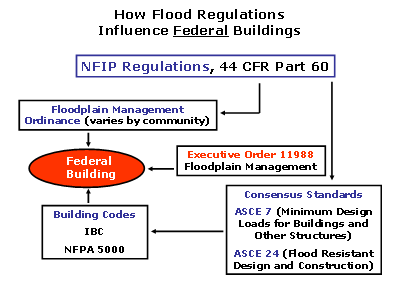
- Determining any flood-related regulatory requirements, for example:
- Community (and State/Regional) floodplain management regulations,
- Applicable building code requirements, and
- for Federal structures and facilities, Executive Order 11988 also applies.
-
Determining design flood characteristics anticipated at the selected site, both now and over the life of the building
- Planning, designing and constructing the building to minimize any potential flood damages by:
- elevating as much of the building as possible above the design flood level,
- designing the building foundation and any portions subject to flooding to withstand design flood conditions and loads, and
- using flood-damage-resistant materials for any portions of the building below the design flood level
- where floodproofing is permitted, employing appropriate methods and materials to either dry-floodproof or wet-floodproof those portions of the building below the design flood level
Identifying Flood Hazards
A number of federal agencies have been involved in identifying flood hazards, but the agency that is most directly involved (also, in the regulation of development within flood hazard areas, and in responding to flood disasters) is the Federal Emergency Management Agency (FEMA). Through its Mitigation Division, FEMA manages the National Flood Insurance Program (NFIP). Definitions and background for common flood hazard and mapping terms used below are available from FEMA.
The NFIP has mapped flood hazards in approximately 20,000 communities within the United States. Specifically, the NFIP has produced a series of maps—Flood Insurance Rate Maps (FIRM), Flood Hazard Boundary Maps (FHBM), and Flood Boundary and Floodway Maps (FBFM)—which depict Special Flood Hazard Areas (SFHA) and Base Flood Elevations (BFEs). Flood Insurance Rate Maps (FIRMs—see Sample below) are the most common of the flood hazard maps. Flood Insurance Study (FIS) reports are produced as part of each flood hazard study and provide data not shown on the FIRMs.
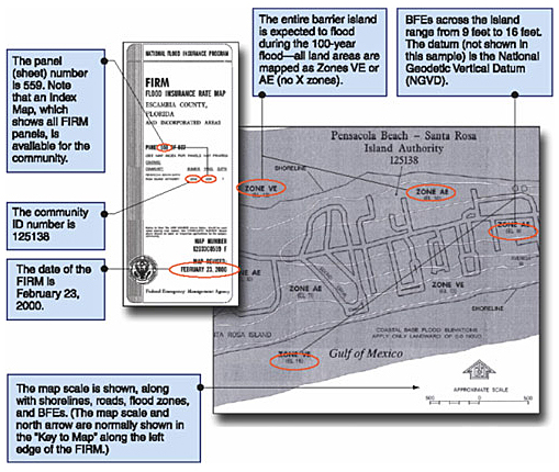
Sample Coastal FIRM
Source: FEMA
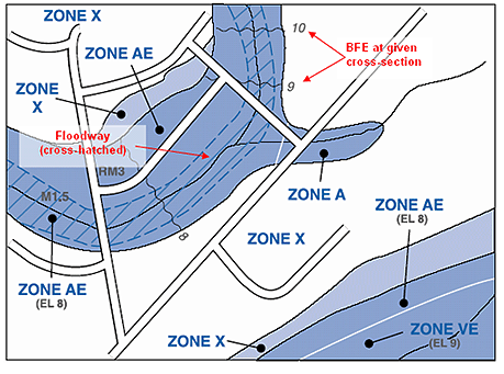
Sample Riverine FIRM
Source: FEMA
The Special Flood Hazard Area is the area known as the 100–year floodplain, or the area subject to flooding during the Base Flood. The Base Flood Elevation (BFE) is the water surface elevation associated with the 100–yr flood, and has a one-percent chance of being equaled or exceeded in any year.
The SFHA is more precisely defined as the floodplain associated with a flood that has a 1–percent annual chance of being equaled or exceeded in any given year. Therefore the SFHA is not associated with a flood event that happens once in a hundred years, it is associated with a flood event that has a one percent chance of occurring each and every year.
The SFHA is usually divided into flood hazard zones beginning with the letter "A" or "V" (see Flood Hazard Zone Table):
- "V" zones are those areas within a coastal floodplain where high velocity wave action can occur during the Base Flood.
- "A" zones are those areas within the 100–yr floodplain where high velocity wave action is not expected during the Base Flood.
"A" zones can be mapped in inland or coastal floodplains. "V" zones are mapped exclusively in coastal floodplains.
The most hazardous floodplain areas will generally be close to coastal shorelines (zone V, also called the coastal high hazard area—CHHA), floodways (areas closest to the centerline of major streams and rivers—see illustration below), and alluvial fans. Special siting and design restrictions and requirements exist for each of these areas.
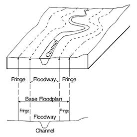
Relationship between Floodway and 100–yr (Base) Floodplain
Source: FEMA
| NFIP Flood Hazard Zones | ||
|---|---|---|
| Special Flood Hazard Area (SFHA) | Zone A | The 100–year or base floodplain. There are seven types of A Zones: |
| A The base floodplain mapped by approximate methods, i.e., BFEs are not determined. This is often called an unnumbered A Zone or an approximate A Zone. | ||
| A1–30 These are known as numbered A Zones (e.g., A7 or A14). This is the base floodplain where the FIRM shows a BFE (old format). | ||
| AE The base floodplain where base flood elevations are provided. AE Zones are now used on new format FIRMs instead of A1–A30 Zones. | ||
| AO The base floodplain with sheet flow, ponding, or shallow flooding. Base flood depths (feet above ground) are provided. | ||
| AH Shallow flooding base floodplain. BFEs are provided. | ||
| A99 Area to be protected from base flood by levees or Federal Flood Protection Systems under construction. BFEs are not determined. | ||
| AR The base floodplain that results from the decertification of a previously accredited flood protection system that is in the process of being restored to provide a 100–year or greater level of flood protection. | ||
| Zone V and VE | Zone V The coastal area subject to a velocity hazard (wave action) where BFEs are not determined on the FIRM. | |
| Zone VE The coastal area subject to a velocity hazard (wave action) where BFEs are provided on the FIRM. | ||
| Outside SFHA or Undetermined Flood Hazard | Zone B and Zone X (shaded) | Area of moderate flood hazard, usually the area between the limits of the 100–year and 500–year floods. B Zones are also used to designate base floodplains of lesser hazards, such as areas protected by levees from the 100–year flood, or shallow flooding areas with average depths of less than one foot or drainage areas less than 1 square mile. |
| Zone C and Zone X (unshaded) | Area of minimal flood hazard, usually depicted on FIRMs as above the 500–year flood level. Zone C may have ponding and local drainage problems that don't warrant a detailed study or designation as base floodplain. Zone X is the area determined to be outside the 500–year flood and protected by levee from 100–year flood. | |
| Zone D | Area of undetermined but possible flood hazards. | |
The NFIP sometimes maps flood hazard zones outside the SFHA (zones "B", "C" and "X") or maps areas of possible but unknown flood hazards, zone "D" (see Flood Hazard Zone Table). Zone "B" has been replaced on newer maps with "shaded zone X", and depicts areas expected to flood at flood recurrence intervals between 100 years and 500 years (0.2 percent to 1.0 percent annual chance of being equaled or exceeded). Zone "C" has been replaced by "unshaded zone X", and depicts those areas with less than a 0.2 percent annual chance of flooding.
A Few Cautions about Flood Hazard Maps
Flood hazard maps, while essential to the planning and design process, should be reviewed carefully for a number of reasons, each of which may affect the accuracy of the flood hazard zones and BFEs shown, and ultimately, may affect the building location, design and construction:
- Although FEMA has plans to update the maps on a national basis, many of the existing maps are old, and conditions might have changed since the maps were produced (e.g., increased development and runoff in riverine areas, shoreline erosion in coastal areas).
- More years of climate and flood data are available now than were available when the maps were produced.
- Better topographic data may be available now than was used as the basis for the maps.
- Hydrologic and hydraulic models have evolved over time, and may yield different results than previous models.
Following review of the FIRM and FIS, designers may wish to supplement those documents with updated calculations and flood hazard zone/flood level estimates. Although not usually required by communities, this step may be important for building planning and design in the case of old and out-of-date flood hazard maps. This step may also be important in the case of a rapidly urbanizing floodplain. Designers should give strong consideration to basing designs on future conditions—rather than present flood hazard conditions.
Obtaining Flood Hazard Maps, Studies and Information
There are several possible sources of flood hazard data. Designers should use one or more of them, as necessary:
-
The date of the latest adopted (effective) FIRM for a given community can be obtained via the NFIP's Community Status Book
-
Copies of the FIRMs and FIS reports, along with supplemental data, are readily available for purchase at FEMA's Flood Map Service Center. FIRMs and FIS reports can be viewed on-line. Digital FIRMs (DFIRMS) may be available for some communities, and will contain much more information than the traditional paper copy FIRMs.
-
Flood risks can be looked up by street address at FEMA's Flood Map Service Center
-
Community officials should have office copies of FIRMS and FIS reports, and should be the best source of any local data and the governing floodplain management ordinance.
Design Flood
Building codes may use the terms Design Flood and Design Flood Elevation (DFE) which do not appear in NFIP regulations. These terms are used to indicate the regulatory flood and flood elevation used by the community or Authority Having Jurisdiction (AHJ); they can equal or exceed minimum NFIP requirements (Base Flood and BFE), but cannot be less than the minimum NFIP requirements:
-
if the community or AHJ has adopted the NFIP's minimum requirements, then the Design Flood will be identical to the Base Flood, and the DFE will be identical to the BFE,
-
if the community or AHJ has adopted a more severe (lower frequency, higher return period) flood than the Base Flood as the basis of its floodplain regulations, the Design Flood will exceed the Base Flood, and the DFE will exceed the BFE,
-
if the community or AHJ has adopted the Base Flood as the basis of its floodplain regulations, but requires freeboard (buildings must be elevated above the BFEs shown on the FIRM), the Design Flood will be identical to the Base Flood, but the DFE will exceed the BFE.
Designers should check with community floodplain management officials to determine whether there are higher regulatory standards than the Base Flood and BFE.
Design Flood Conditions and Loads
Flood-resistant design requires the characterization of flood conditions during the design flood, including:
- source of flooding
- flood depth
- flood velocity
- flood duration
- rate of rise and fall
- wave effects
- flood-borne debris
- scour and erosion
Flood source is usually, but not always, obvious (also, consider the possibility of multiple flood sources at a site). Flood depth will be the easiest flood parameter to determine, using the FIRM and FIS (updated, if required), plus site topography. Flood velocity, duration, rate of rise/fall, debris loads and scour/erosion will be more difficult to determine, and may require consultation with hydraulic engineers. For sites in coastal areas, consultation with a coastal engineer may be needed.
Guidance for computation of flood loads can be found in section 5.3 of SEI/ASCE-7. The document includes calculation of hydrostatic (including buoyancy), hydrodynamic (flowing water), wave and flood-borne debris impact loads, and has been referenced by model building codes.
Finally, designers are advised that flood-resistant design differs from design for other environmental loads, in that flood resistance depends heavily on avoidance of the hazard, not just on resisting the hazard. While all structural elements below the DFE must be designed to resist flood loads, the consequences of a flood level exceeding the floor/floodproofing elevation (even by a small amount) can be extreme, especially in coastal areas and in riverine areas with heavy debris loads. Designers are advised to be conservative when calculating design flood conditions and elevations.
Future Conditions
Designers should note that, typically, flood hazard mapping has been based on "present" conditions. "Present" conditions usually means: land use, land cover, topographic, and hydraulic conditions at the time of the study in riverine areas; and shoreline location, characteristics and topography at the time of the study in coastal areas). Flood hazard mapping has rarely reflected future watershed development and future shoreline erosion.
This mapping procedure may change for riverine areas on a case-by-case basis, since FEMA may now consider future conditions hydrology in its flood mapping efforts (if the community being studied requests the change and participates in the study). Also, some communities have already performed independent future conditions flood hazard mapping.
Designers should determine whether the flood hazard map is based on "present" conditions (i.e., those at the time the FIS was completed) or on future floodplain conditions. If the map is not based on future conditions, designers should: 1) consider the impacts of future conditions on local flood hazards over the lifetime of the building, and 2) adjust the design flood conditions and loads to reflect future conditions if a significant increase in flood hazards is expected.
Floodplain Management Requirements
While flood hazards have been mapped by the NFIP on a nationwide basis, floodplain management regulations are adopted and decisions are made at the local level. Communities that choose to participate in the NFIP must adopt local floodplain management regulations (no less stringent than minimum NFIP regulations), and in return, building owners and renters in the community are eligible to purchase flood insurance through the NFIP, and the community is eligible for certain types of flood disaster assistance.
The vast majority of communities participate in the NFIP, and the NFIP floodplain management requirements (44 CFR 60) are administered at the community level (usually through the adoption of a floodplain management ordinance, zoning or subdivision regulations, and a recent model building code), with some states and regional governments mandating additional requirements.
Floodplain management requirements, when reduced to their simplest form, govern the lowest floor (including basement) elevation and foundation of a building, the materials and methods used to construct lower portions of the building, and (sometimes) the location of the building. Most of the requirements are performance requirements rather than prescriptive requirements (exceptions include the lowest floor elevation in all flood hazard zones, and the foundation type in a V zone).
Floodplain management requirements typically pertain to all development activities in a mapped floodplain, with development being viewed broadly (e.g., any man-made change to improved or unimproved real estate, including but not limited to buildings or other structures, mining, dredging, filling, grading, paving, excavation or drilling operations or storage of equipment or materials).
Federal Buildings: Executive Order 11988
Federal structures and facilities are also governed by Executive Order 11988, whose pertinent sections are summarized below:
-
Before taking an action, each Federal agency shall determine whether the proposed action will occur in a floodplain.
-
Requires Federal agencies to avoid, to the extent possible, the long- and short-term adverse impacts associated with the occupancy and modification of floodplains and to avoid the direct and indirect support of floodplain development whenever there is a practicable alternative.
-
The construction of Federal structures and facilities is to be in accordance with the standards and criteria of, and to be consistent with the intent of those promulgated under, the National Flood Insurance Program.
-
Federal structures and facilities shall deviate only to the extent that the standards of the Flood Insurance Program are demonstrably inappropriate for a given type of structure or facility.
Fundamentals
The fundamental goal of flood-resistant construction is for buildings to resist flotation, collapse and permanent lateral movement during the design flood.
To achieve this, the basic design requirements are as follows:
- have the lowest floor (including basement):
- elevated to or above the design flood elevation (Note that this discussion states that the lowest floor must be elevated to or above the DFE. In fact, model building codes and some floodplain management regulations add freeboard, and require lowest floors to be set above the DFE in certain instances. Designers should determine any specific freeboard requirements for their projects, based on applicable regulations and code requirements).
OR - for non-residential buildings only—be designed so that the building (and its attendant utility systems) are watertight below the design flood elevation (dry-floodproofed) with walls substantially impermeable to the passage of water and with structural components having the capability of resisting hydrostatic and hydrodynamic loads and effects of buoyancy (NOTE: dry-floodproofing is not permitted in V zones)
- elevated to or above the design flood elevation (Note that this discussion states that the lowest floor must be elevated to or above the DFE. In fact, model building codes and some floodplain management regulations add freeboard, and require lowest floors to be set above the DFE in certain instances. Designers should determine any specific freeboard requirements for their projects, based on applicable regulations and code requirements).
-
support the building on a foundation designed and constructed to resist all anticipated flood loads, in combination with other anticipated loads
-
construct the building with flood damage resistant materials below the design flood elevation
-
in areas outside the V zone, and for buildings not dry-floodproofed, incorporate flood openings in walls forming an enclosure below the DFE, to allow the automatic equalization of flood levels
-
in V zones, or in other areas subject to extreme lateral flood loads, elevate the building on piles or columns (minimize the use of shear walls below the DFE, wherever possible), keep the area below the DFE free of obstructions that could transfer flood loads to the elevated building, and use breakaway construction for any non-structural building elements
"Successful" Building Designs
A "successful" building will resist flood loads and other loads over a period of decades, and will exhibit the following characteristics:
- any flood damage will be minor and easily repairable
- the foundation will remain intact and fully functional following a design flood
- any breakaway enclosures below the DFE will break free without causing damage to the elevated building, the foundation, building access structures, or utility systems
- the building envelope will remain sound
- utility connections will be intact or easily restorable after a design flood
- the building will be accessible and usable after a design flood
Lowest Floor Elevation
Buildings within the Special Flood Hazard Area must have their lowest floor (including basement) elevated to or above the DFE (except for non-residential buildings which are dry-floodproofed). Specific lowest floor elevation requirements—tied to the flood hazard zone and the building classification in Section 1 of SEI/ASCE-7 building classification—are contained in SEI/ASCE-24, which is referenced by the IBC and NFPA 5000.
In A zones, the reference level for the lowest floor (including basement) is at the top of the floor; in V zones, the reference level for the lowest floor is set at the bottom of the lowest horizontal structural member supporting the lowest floor.
Thus, in riverine A zones, the top of the lowest floor must be set at or above the DFE (Designers should know that setting the top of the lowest floor at the DFE does not, by itself, eliminate potential flood damage during the design flood—construction materials below the DFE must be flood damage resistant. In some cases it may be easier and less expensive to elevate the bottom of the floor system above the DFE than to construct the entire lowest floor system with flood damage resistant materials).
In V zones, buildings must have the bottom of the girder, floor beam or floor joist for the lowest floor at or above the DFE.
Floodproofing
Floodproofing is the process of making a building resistant to flood damage, either by taking the building out of contact with floodwaters or by making the building resistant to any potential damage resulting from contact with floodwaters. (Note that this discussion states, where permitted and used, floodproofing must extend to the DFE. In fact, model building codes and some floodplain management regulations require floodproofing to extend to levels above the DFE in certain instances. Designers should determine any specific floodproofing elevations for their projects, based on applicable regulations and code requirements).
Floodproofing can be subdivided into several categories:
Dry-floodproofing requires use of special sealants, coatings, components and/or equipment to render the lower portion of a building watertight and substantially impermeable to the passage of water (see illustration of Typical Dry-Floodproofing Techniques below).
Wet-floodproofing allows the uninhabited lower portion of a building to flood, but uses materials that will not be damaged by flooding.
Active floodproofing, sometimes known as contingent (partial) or emergency (temporary) floodproofing, requires human intervention to implement actions that will protect a building and its contents from flooding. Successful use of this technique requires ample warning time to mobilize people and equipment and floodproofing materials.
Passive floodproofing, sometimes referred to as permanent floodproofing, requires no human intervention—the building (and/or its immediate surroundings) is designed and constructed to be floodproof without human intervention.
Examples of floodproofing methods are shown in the table and illustration below.
| Examples of Floodproofing Methods for Buildings | ||
|---|---|---|
| dry | wet | |
| active |
|
|
| passive |
|
|
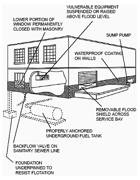
Typical Dry-Floodproofing Techniques
Source: FEMA
The figure above illustrates that floodproofing involves more than the building envelope—it also involves penetrations through the envelope and associated utility systems. Guidance on floodproofing utilities can be found in FEMA P-348, Protecting Building Utility Systems from Flood Damage.
Designers should be advised that there is an approximate equivalence between some of the floodproofing terms used in this Resource Page and in other WBDG Resource Pages, specifically, dry-floodproofing ≈ waterproofing, and wet-floodproofing ≈ damproofing. See WBDG Below Grade Systems Resource Page on Foundation Walls.
Dry-Floodproofing
Dry-floodproofing is permitted by floodplain management regulations and model building codes for some, but not all, flood hazard areas and types of buildings. Specific dry-floodproofing prohibitions are as follows:
-
Because of potential structural failures, dry-floodproofing of spaces below the DFE is not permitted for buildings in V zones.
-
Because of potential harm to building occupants, dry-floodproofing of spaces below the DFE (in A zone buildings) is only permitted for non-residential occupancies.
-
Where certificate permitted, one of the requirements of dry-floodproofing is that the dry-floodproofed elements of the building envelope be substantially impermeable to the passage of water. According to FEMA's NFIP Technical Bulletin 3, Non-Residential Floodproofing Requirements and Certifications, substantially impermeable means the walls and floor shall not permit the accumulation of more than 4 inches of water depth during a 24–hour period if there were no devices provided for its removal. However, sump pumps shall be required to control this seepage. Designers should note that the same requirement would apply to any subgrade portion of the envelope below the DFE, including plazas, tunnels and vaults.
The NFIP use of the phrase "substantially impermeable" is taken from the USACE Flood Proofing Regulations , Floodproofing Class W2 (Essentially Dry) classification, as shown in the table below.
Thus, according to the NFIP, a space classified as W2 or W1 would be considered to be dry-floodproofed.
| NFIP/USACE Classification of Floodproofed Space | ||
|---|---|---|
| NFIP Classification | USACE Floodproofing Class | USACE Class Description |
| Dry-Floodproofed | W1 | completely dry: envelope impermeable to water and water vapor; designed for hydrostatic and hydrodynamic loads. |
| W2 | essentially dry: envelope substantially impermeable to water, but may pass some water vapor or seep slightly; designed for hydrostatic and hydrodynamic loads. | |
| Wet-Floodproofed | W3 | intentionally flooded with potable water: wet flood proofing; hydrostatic pressure equalized. |
| W4 | flooded by flood water: wet flood proofing; hydrostatic pressure equalized. | |
| Not Floodproofed | W5 | non-flood proofed: (fails to meet any of above) |
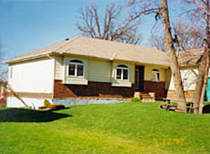
Failure of Lightweight Building with a Dry-Floodproofed Basement, Lifted out of the Ground by Buoyant Forces during a Flood
Source: USACE
Designers should calculate the lateral hydrostatic forces and the vertical buoyant forces on a structure containing a dry-floodproofed area. These forces can be quite large, and in the case of small or lightweight buildings, can be sufficient to cause walls to fail or buildings to float out of the ground (see photo at right). Designers should be aware that the use of dry-floodproofing triggers a requirement for a floodproofing certification.
Sealants, Flood Shields and Valves
A wide variety of materials and devices have been developed to make building walls, floors, openings, penetrations and utilities watertight during flooding. General guidance on the topic can be found in Flood Proofing Regulations , (USACE, 1995).
Flood shields, panels, doors and gates are typically used to close medium to large openings in building walls. They can be temporary closures that are installed only when a flood threatens, or they can be permanent features that are closed manually or automatically. Key design parameters of these barriers are their height, their stiffness (and resistance to hydrostatic forces), their method of attachment or installation, and their seals and gaskets.
As a general rule, flood shields, panels, doors and gates should not be attached to building windows, glazing or doors. Given the potential for large flood loads, they should be attached to exterior walls or the structural frame. Coordination with the design of exterior walls and fenestration is required.
Designers planning to incorporate flood shields, panels, doors or gates into a building design are advised to consult with engineers and vendors experienced with the design and installation of these components.
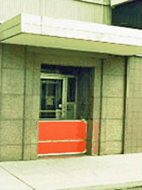
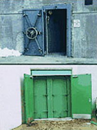
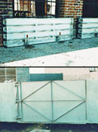
Temporary Flood Panel, and Permanent Flood Doors and Gates
Source: Presay Corp.
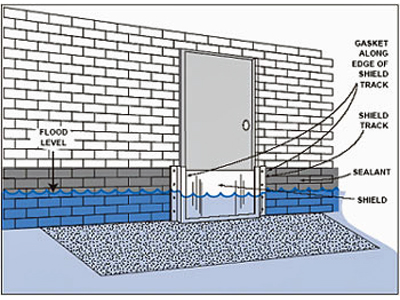
Temporary Flood Shield Held in Place by Permanent Metal Track
Source: FEMA
Backflow valves are often installed to prevent drains and sewers from backing up into a building, and are an important component of floodproofing. They are relatively inexpensive to install and simple to operate.
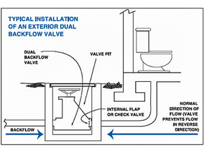
Backflow Prevention Valve
Source: FEMA
Wet-Floodproofing
Wet-floodproofing is employed commonly in parking garages, building access areas, crawlspaces and similar spaces. It is not employed in spaces where offices, commercial activity, residential uses and/or similar uses take place.
There are two principal methods used in to wet-floodproof areas below the DFE:
- in enclosed areas, installation of flood openings or vents in walls to allow the automatic equalization of flood levels on both sides of the walls (and to prevent wall failures due to unbalanced hydrostatic loads), and
- use of flood-resistant materials.
A space classified as W3 or W4 would be considered wet-floodproofed by the NFIP.
Additional guidance on wet floodproofing can be found in FEMA Technical Bulletin 7, Wet Floodproofing Requirements.
Flood Openings
Unless dry-floodproofed, enclosed areas below the DFE must be equipped with flood openings capable of equalizing water levels and hydrostatic loads. The use of flood openings (also called flood vents, since vents are commonly installed in the openings) is discussed in NFIP Technical Bulletin 1, Openings in Foundation Walls and Walls of Enclosures. Since owners usually want to control temperature and moisture in these enclosed areas (and prevent rodents, birds and insects from entering), opening covers are often employed. These covers must not interfere with the equalization of water levels in the event of a flood, and should be selected to minimize potential blockage by debris. There are a variety of commercially available covers, such as grates, louvers and grills (see illustration below) that allow for control of the enclosed space and the passage of floodwaters.
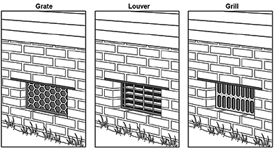
Typical Flood Opening Covers
Source: FEMA
The location, number and size of the openings are specified in Section 2.6 of SEI/ASCE-24, which, in turn, is referenced by both the IBC and NFPA 5000.
Two methods of sizing the openings are permitted, a prescriptive (non-engineered) method and an engineered method. Both methods have similar requirements related to: openings in multiple walls; the elevation of the bottoms of the openings (to be no more than one foot above the adjacent ground level); minimum opening size (three inches in the plane of the wall).
However, the two methods use different procedures to calculate the total net area of required openings. The prescriptive method calls for one square inch of flood opening for each square foot of enclosed area below the DFE, and is based on conservative assumptions regarding flood characteristics and flow through the openings. The engineered method allows designers to size openings based on site-specific flood characteristics and opening shapes. The engineered method usually results in a smaller total net opening area than the prescriptive method does, however, use of the engineered method triggers a requirement for a flood opening certification.
Levees and Floodwalls
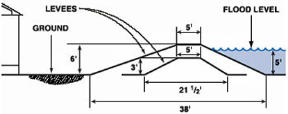
Levees and floodwalls are barriers constructed away from a building as a means of preventing floodwaters from reaching the building. Permanent barriers are typically constructed of earth, concrete or metal. Temporary barriers are typically installed using sand bags or water-filled tubes. Permanent barriers will typically require gates or doors at any locations where normal building access (vehicular and pedestrian) is maintained. Drainage systems will be required inside levees and floodwalls to remove rainfall that is trapped behind the barrier, and to remove floodwaters that enter through leaks in the barrier or seep through the ground.
Designers are advised not to rely on temporary barriers for flood protection, and those contemplating use of a permanent levee or floodwall are advised to consult with engineers experienced in the design and construction of these structures.
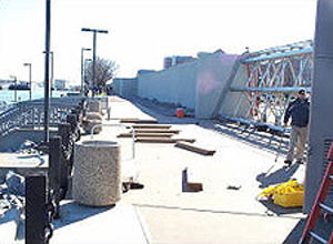
Floodgate Being Installed to Close Floodwall
Source: National Weather Service
Cross-Section of Typical 3–ft High Levee and 6–ft High Levee, Showing the Difference in the Levee Width
Source: FEMA
Building Foundation
Buildings in the SFHA must be elevated to or above the DFE using foundations appropriate to the flood hazard zone within which the building is situated. In the case of A zones, the NFIP allows any foundation type—slab, crawlspace, solid foundation walls, piers, posts, piles, columns—provided the foundation meets the requirements of the Authority Having Jurisdiction (AHJ) (building code and regulations), and provided the foundation will resist anticipated design flood conditions and loads. The NFIP permits buildings to be elevated and supported by fill in A zones, but requires the fill be protected against erosion, if necessary.
In V zones, the NFIP restricts foundations to pile or column foundations, with the space between the piles and columns free of obstructions or of breakaway construction, as discussed in NFIP Technical Bulletin 5, Free-of-Obstruction Requirements for Buildings Located in Coastal High Hazard Areas. The intent of the free-of-obstruction and breakaway wall requirements is to minimize the structural elements exposed to breaking waves, high velocity flow and flood-borne debris forces.
The NFIP does not permit the use of fill to elevate and support buildings in V zones. The NFIP does not permit slab foundations, or crawlspace foundations, or basements, or solid foundation walls in V zones. However, the use non-breakaway walls around building access points (stairwells, elevators, etc.) and limited shear wall usage has been permitted in certain cases (e.g., fully-engineered, high-rise buildings which require the use of solid walls to transfer wind or seismic loads to the ground). Designers should consult with the AHJ early in the planning process to ascertain what will and will not be allowed.
Flood-Resistant Materials
Floodplain management regulations and model building codes both require materials used below the design flood elevation to be flood-resistant. But, what exactly are flood-resistant materials?
According to the NFIP, flood-resistant materials are those materials that are capable of withstanding direct and prolonged contact with floodwaters, without sustaining significant damage; direct and prolonged contact means at least 72 hours; significant damage means any damage requiring more than low-cost cosmetic repair (such as repainting). Designers are advised that interior finishes below the DFE must also be flood-resistant.
Additional NFIP guidance, although somewhat dated, is contained in FEMA Technical Bulletin 2, Flood Damage-Resistant Materials Requirements. The technical bulletin adopts a materials classification from the USACE Flood Proofing Regulations , with five classes of flood-resistance, as summarized in the table below. The NFIP has determined that class 5 and 4 materials are flood-resistant; class 3, 2 and 1 materials are not judged flood-resistant by the NFIP.
| NFIP Classification of Flood-Resistance of Materials | ||
|---|---|---|
| NFIP Acceptability | Material Class | Material Class Description |
| Acceptable | 5 | Highly resistant to floodwater damage. Materials within this class are permitted for partially enclosed or outside uses with essentially unmitigated flood exposure. |
| 4 | Resistant to floodwater damage. Materials within this class may be exposed to and/or submerged in floodwaters in interior spaces and do not require special waterproofing protection. | |
| Unacceptable | 3 | Resistant to clean water damage. Materials within this class may be submerged in clean water during periods of intentional flooding. |
| 2 | Not resistant to water damage. Materials within this class require essentially dry spaces that may be subject to water vapor and slight seepage. | |
| 1 | Not resistant to water damage. Materials within this class require conditions of dryness. | |
(Source: FEMA (1993), based on USACE Flood Proofing Regulations)
A test protocol was developed to allow the flood-resistance of materials and components to be evaluated. Designers may wish to utilize this protocol if the flood resistance of a particular material is in question.
Certifications
Several flood-resistance certifications can be required in flood hazard areas. These are discussed generally below, but designers are advised to consult the AHJ to determine exact certification requirements and certification forms.
-
Lowest Floor Elevation Certification: the elevation of the lowest floor (including basement) of a building in the SFHA must be measured, and a certification form must be completed.
-
Flood Openings Certification: where engineered openings are used for enclosed areas below the DFE—in lieu of openings sized using the prescriptive method—a flood opening certification form must be completed. The certification must state that the openings will allow for the automatic entry and exit of floodwaters and meet the requirements of SEI/ASCE-24.
-
Dry-Floodproofing Certification: for nonresidential occupancies below the DFE, a certification must be completed. The certification must state: 1) the elevation to which the building has been dry-floodproofed, 2) that the building, together with utilities and sanitary facilities, is watertight to the floodproofed elevation, with walls that are substantially impermeable to the passage of water, and 3) that the structure is capable of resisting hydrostatic and hydrodynamic and debris impact forces, including the effects of buoyancy.
-
V Zone Design and Construction Certification: for buildings constructed in the V zone, a certification must be completed. The certification must state: 1) the design and methods of construction are in accordance with accepted standards of practice, 2) the bottom of the lowest horizontal structural member supporting the lowest floor (including basement) is at or above the DFE, and 3) the foundation and the structure attached thereto are anchored to resist flotation, collapse and permanent lateral movement due to the effects of the design flood in combination with other loads, as specified by the building code.
-
Breakaway Wall Certification: in V zones, where breakaway walls below the DFE are designed to break away at lateral loads greater than 20 psf, a certification must be completed (no certification is required where breakaway walls are designed to break away at lateral loads less than or equal to 20 psf). The certification must state the breakaway walls are designed to collapse from a flood load less than that which will occur during the base flood.
Applications
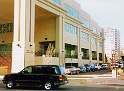
Example of Flood Proofed Public Building, Reno, Nevada
Photo Credit: USACE
There are countless examples of building failures during floods, and almost all are a direct result of violating one or more of fundamental flood-resistant design requirements. There are also many examples of buildings that have successfully resisted design floods.
Building performance during floods, both good and bad, has been investigated by the US Army Corps of Engineers National Nonstructural Flood Proofing Committee and by FEMA's Mitigation Assessment Team Program, and both have issued several publications that will be of use to designers.
Emerging Issues
One emerging issue is the application of V zone design and construction requirements in Coastal A Zones. While the NFIP maps many V zones based on a 3–ft wave height, numerous post-storm investigations have found that many A zone buildings are severely damaged or destroyed during coastal flood events. The damage is usually due to either, the undermining of shallow foundations, or wave and debris loads destroying foundation walls and crawlspace foundations.
The Coastal A zone has been incorporated into several documents and standards:
-
FEMA P-55, Coastal Construction Manual recommends use of V zone design and construction practices in A zones which are subject to breaking waves, high velocity flow and foundation scour/erosion.
-
Section 2 of SEI/ASCE-7 includes different load combinations for coastal A zones and non-coastal A zones.
-
The 2005 edition of SEI/ASCE-24, which will likely be referenced by the the newest editions of the IBC and NFPA 5000, defines the coastal A zone as the area subject to wave heights greater than or equal to 1.5 ft, and mandates V zone type construction in the coastal A zone.
-
The NFIP Community Rating System gives flood insurance premium discounts to coastal communities that enforce V zone standards in A zones.
Another emerging issue is the rapid development of new construction materials and systems, whose long-term resistance to water intrusion and degradation is unknown. As these new products and systems are incorporated into buildings, time will ultimately gauge their success or failure. While a test protocol has been developed to test the flood resistance of materials over a 72–hour period, tests duplicating the long-term, in situ performance of materials and systems are generally less reliable.
Relevant Codes and Standards
Federal Mandates
Codes and Standards
There are two model codes that may govern the design and construction of office buildings: the International Building Code (ICC, 2009) and NFPA 5000: Building Construction and Safety Code® (NFPA, 2009). The flood-resistance provisions of both codes are consistent with NFIP requirements.
Both, the IBC and NFPA 5000, reference two standards important to flood-resistant design: SEI/ASCE-7 (Minimum Design Loads for Buildings and Other Structures), and SEI/ASCE-24 (Flood Resistant Design and Construction).
The 2002 edition of SEI/ASCE-7 and the 1998 edition of SEI/ASCE-24 are referenced by the latest editions of the IBC and NFPA 5000 (both codes refer to the flood loads and load combinations contained in SEI/ASCE-7; both codes require design and construction within flood hazard areas to comply with SEI/ASCE-24). However, 2005 editions of SEI/ASCE-7 and SEI/ASCE-24 will be issued, and both codes are undergoing a new revision cycle at this time. Designers should check with the AHJ regarding use of the latest versions of these codes and reference standards.
IBC (2009)
Most of the mandatory provisions are contained in Section 1612 (Flood Loads), but others also occur in:
- Section 106.2 (Site Plan)
- Section 109.3.3 (Lowest Floor Elevation Inspection)
- Section 202 (Definitions)
- Section 801.3 (Interior Finishes, flood resistance)
- Section 1107.7.5 (Accessibility, Dwelling and Sleeping Units)
- Section 1203.3.2 (Under-Floor Ventilation)
- Sections 1403.6 and 1403.7 (Exterior Walls, Performance, Flood Resistance)
- Section 1603.1.6 (Construction Documents, Flood Loads)
- Section 3001.2 (Elevators, Reference Standards)
Optional Provisions, that jurisdictions may or may not adopt, are included in: Appendix G (Flood-Resistant Construction) and Section J101.2 (Grading, Flood Hazard Areas).
NFPA 5000 (2008)
Most of the mandatory provisions are contained in Chapter 39 (Flood-Resistant Design and Construction), but others also occur in:
- Section 1.7.6.6.3.4 (Lowest Floor Elevation and Inspection)
- Section 3.3 (Definitions)
- Section 4.1.3.2.2.2 (Safety from Structural Failure Objectives)
- Section 5.3.2.1 (Performance Based Design)
- Chapters 15 through 32 (occupancy chapters contain cross-references to Chapter 39)
- Chapter 35 (structural design chapter—contains flood provisions related to construction documents, flood loads, buoyancy, and load combinations)
- Section 36.2.4.2 (Use of Fill)
- Section 36.4.5 (Use of Soil Bearing Foundations)
- Section 36.5.1.7 (Use of Pile Foundations)
- Section 36.6.1.3 (Foundation Walls)
- Section 36.8.5 (Site Grading)
- Section 37.1.1.2 (Exterior Walls, Flood Resistance)
- Chapters 50, 52, 53 and 54 (Mechanical, Electrical, Plumbing and Elevator systems to comply with SEI/ASCE-24)
- Section 55.1.6 (Fire Protection Systems, conflicts with flood requirements)
Optional Provisions, that jurisdictions may or may not adopt, are included in: Annex C (Flood-Resistant Construction).
SEI/ASCE-7
SEI/ASCE 7-10 (Minimum Design Loads for Buildings and Other Structures) includes flood load calculation methods that are referenced by the IBC, NFPA 5000 and SEI/ASCE-24. The document represents the national standard for loads and load combinations. The SEI/ASCE-7 building classification system is used by SEI/ASCE-24 to establish variable design and construction requirements for buildings of different importance categories. The flood load section of SEI/ASCE-7 has remained largely unchanged since undergoing major revisions in 1998, with the exception of the addition of expanded commentary language dealing with the calculation of flood-borne debris impact loads in 2002.
SEI/ASCE-24
SEI/ASCE 24-14 (Flood Resistant Design and Construction) was first published in 1998. The standard establishes basic requirements for design and construction in A zones and V zones, consistent with but sometimes exceeding the NFIP minimum requirements. One way in which the standard exceeds the NFIP minimum requirements is by requiring freeboard (elevating higher than the NFIP requires) for the lowest floor (including basement) and equipment, for the use of flood-resistant materials and for floodproofing; more important building categories require more freeboard.
A second edition published in 2005, contains many changes from and improvements to the 1998 edition. The most significant change is the incorporation of the coastal A zone into the standard, and the extension of V zone design and construction requirements into the coastal A zone.
Additional Resources
Publications
- Applied Technology Council, 2004. ATC-45—Field Manual: Safety Evaluation of Buildings after Windstorms and Floods. This pocket-sized and water-resistant inspection manual with a complement of reporting forms is suitable for post-disaster field use.
- Buying a Home in a Higher-Risk Flood Zone: What to Know by Alexis Bennett. Mobile, Alabama: Today’s Homeowner, 2023.
- SEI/ASCE 24-14, Flood Resistant Design and Construction.
- SEI/ASCE 7-10, Minimum Design Loads for Buildings and Other Structures.
- Technical Bulletin 1, Openings in Foundation Walls and Walls of Enclosures.
- Technical Bulletin 2, Flood Damage-Resistant Materials Requirements
- Technical Bulletin 3, Non-Residential Floodproofing Requirements and Certifications
- Technical Bulletin 5, Free-of-Obstruction Requirements
- Technical Bulletin 7, Wet Floodproofing Requirements
- FEMA 338, Building Performance: Hurricane Georges in the Gulf Coast
- FEMA 348, Protecting Building Utilities from Flood Damage
- FEMA P-55, Revised Coastal Construction Manual
- International Code Council, NES Evaluation Protocol for Determination of Flood Resistance Properties of Building Elements
- International Code Council, International Building Code
- National Fire Protection Association, NFPA 5000 Building Construction and Safety Code
- National Flood Insurance Program Regulations — Land Use — 44 CFR Part 60
- US Army, Corps of Engineers, Flood Proofing Regulations , National Flood Proofing Committee. USACE 1995.
- US Army, Corps of Engineers, Flood Proofing Performance: Successes and Failures USACE 1998.


